
Visual Augmented Reality Assistant for Spatial Mapping
VizARd bridges the gap between the output of a digital planning step and the mapping onto real world objects.
- Static and/or mobile AR devices were uniquely combined with environment-perceiving 2D and 3D sensors,
- Novel non-rigid registration methods enabled a precise mapping on deformable surfaces and
- Real time position detection of objects as well as location-aware devices permitted high-quality AR presentations.
The proposed methodology and its applicability was evaluated and presented for two distinct domains:
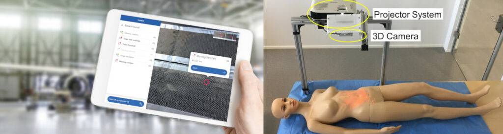
- In the medical domain, perforator flap surgery requires the topographic marking of blood vessel locations – derived from a digitally supported workflow – on the patient’s skin. See the following video for some impressions of VizARd’s results: https://youtu.be/OelQkfsOn3c
- In the industrial domain, defect visualization in Carbon-Fiber-Reinforced Polymer (CFRP) production are extensively used in the aeronautic and wind power industry, and need to be detected by an inspection system followed by visualization on the object, which is then repaired. The following video provides some insights: https://youtu.be/o-9xynv8Z_M
A noteworthy aspect of VizARd was the continuous utilization of user experience methods from the very beginning of the project. The integral involvement of users ensured the acceptance of the final technology, which was of utmost importance in both domains.
Project name:
VizARd (Visual Augmented Reality Assistant for Spatial Mapping)
Funding:
FFG – ICT of the Future
Duration:
November 2018 – April 2021

Your Contact
DI(FH) Harald Bauer
Head of Visual Computing
+43 7252 885 302
harald.bauer@nullprofactor.at
We answer…
Project partners:
PROFACTOR GmbH
